Walk of the month: Historic Strathalbyn township
Graham Hallandal guides you on a walk around the heart of this town on the edge of the Murraylands, Adelaide Hills and Fleurieu Peninsula.

Autumn in the Murraylands is usually a time of many sunny, windless days with temperatures in the mid to high 20s: ideal walking weather.
This year it will hopefully be similar.
This month’s walk involves a short drive.
For those still working, it’s ideal for an outing on a weekend with friends or the family, with a breakfast or brunch stop on the way plus exercise as a bonus.
If you’re on holidays or retired, go any day you want to.
This walk is in Strathalbyn, with easy access to the historical architecture preserved in the town.
Most of us drive through Strathalbyn on the way to the south coast, but take the trouble to look closer and I think you will be impressed.
This is a walk well worth taking to experience some of the more than 30 heritage-listed buildings there.

The start of the walk is at the Strathalbyn Railway Station on South Terrace.
If coming from Murray Bridge, it is located on the left as you enter the town.
Copies of the brochure on which this walk is based, including a map, are available to download below; or in hard copy from the Strathalbyn Visitor Centre, located in the railway station building.

Strathalbyn: A Walk Around the Town5.36MB ∙ PDF fileDownloadDownload
Strathalbyn was settled more than 180 years ago by Scottish immigrants.
The word strath is used in Scotland to mean a wide, flat river valley; Albyn is the ancient Celtic name for Scotland.
The Adelaide Chronicle of August 26, 1840 reported the area as the Strath-Albyn district, and that it was especially well stocked and incorporated 12 stations, with many sheep, cattle and horses, and a town with an inn and store which had just been laid out.
The railway arrived in town in 1883 from Mount Barker, with the railway station completed in 1884 and steam replacing the horse tram to the south coast in 1885.
To start the walk, follow the blue line on the map: cross South Terrace and head along the west side of Dawson Street, the best location to view the architecture of the building across the road in the first section.
The numbers on the map show points of interest.
The Christian chapel opened in 1873, the Masonic Hall in 1896 and the spectacular Savings Bank, now Bank SA, was built in 1930.

On the corner of Dawsons Street and Albyn Terrace are Mr Woolfitt’s Bakery, built in 1854, now shops and offices; and the Victoria Hotel of the 1860s.
Dawson Street now becomes Commercial Road.
On it are the 1914 post office and Angus House, now a gift shop.
Opposite, in the park, is the pedestrian Mill Bridge, built in 1913, which leads to a bandstand from 1912 as well as public toilets.
Commercial Street crosses the Dawson Creek over Mill Bridge.
The weir was once the town swimming pool.
To the left are “Watervilla” and the mill on the corner of Mill Street, with a large grain store built in the 1860s opposite.


Originally a small tram line crossed the road between the mill and grain store.
The building with pillars across the road was originally a gas works, then the power station from 1917 until 1939, when it was remodelled as the corporation chambers.
Blackwell House opposite, on Colman Terrace, was built in the 1860s as a general store and later became a butcher’s shop.
A short detour down Dawson Street is the original primary school, now the council offices and library.
The cairn opposite commemorates the location of Strathalbyn’s first cemetery.
Back on Commercial Road, at location 23, is the former Wesleyan church, now the Chapel Theatre.


Through to the end of Commercial Street, mainly well-kept heritage buildings exist.
At the intersection of North Parade, on the left, hidden by walls and hedges is a large house known as the Doctor’s House, built in the 1860s.
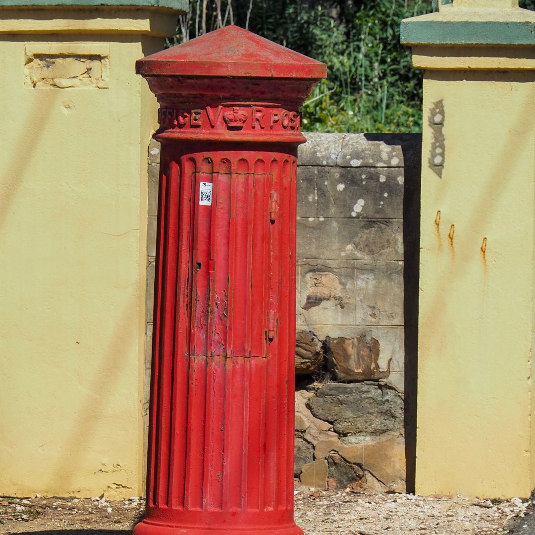
It is on this corner where an old circular postbox for letters still sits.
A short detour towards West Terrace is Noye’s School, built in 1857.
Back track and continue along North Parade.
Opposite, the building is Dollar Cottage, built in 1860; the heritage-listed house and associated shop add much character to the corner of North Parade and Melville Street.

A distinctive curved parapet roof, brick coping and stone rubble walling draws passers-by to its more-than-160-year-old charm.
It was once nicknamed “Hoot Hall” because of a previous owner’s obsession with collecting owls.
Moving along, the old Rechabite Hall was once a school.
Cross the Angus River, noting a walking track on the riverbank.
This trail is a section of the River Angus Walkway, a 4.7-kilometre out-and-back dog and pram-friendly walk popular for walking, running, and birding, highly recommended for a quiet, scenic, easy walk.
Turn right into Sunter Street, then left into High Street.
Adjacent buildings dating from the 1850s included a blacksmith.
Public toilets are in the park.

Is it time for breakfast, brunch, or a stop for coffee?
In this area is a wide selection of locations, open all weekend.
On my last count, Strathalbyn has 17 places open on weekends to eat.
With a population of around 7000, it is quite a contrast to the number of Murray Bridge options available on Sundays, with less than a third of the population.
There is a lot of history in the next short section of cafes and shops.
London House, fully restored as an antique shop, was built in 1867, with stables in the rear used by Hill and Co Coach Lines.

The Robin Hood Hotel dates to 1855, Holloway’s Bakery to 1850, the town hall was built in 1874 and has been enlarged several times, and a row of two-story structures was built in 1867.
If you are a motoring enthusiast, then there are two attractions you must visit.
The first is Gilbert’s Motor Museum, in High Street on the left; manned by volunteers, it contains motoring history, motorcycles, vintage, veteran, classic, muscle cars and more in an extensive, century-old former garage and showrooms.
Turn right into Swale Street.
On the corner of High Street is the Commercial Hotel, built in 1865 and enlarged and re-roofed in 1872.
In this short street are an old carpenter’s shop with two workman’s cottages next door.
On the next corner with Sunter Street is a two-story building which once housed the Commercial Bank.
Opposite the intersection on Sunter Street is Bells Corner, built in the 1860s, then purchased by David Bell in 1869 as Bells Store and enlarged several times.
Cross onto the footpath adjacent to the park.
The war memorial has unusual bronze relief panels of a soldier and a cavalry charge.
Close by, on the river bank, some old eucalypts show the scars left when Aboriginal canoes and shields were cut from the then-living bark.
Across the street stands St Andrew’s Uniting Church, which dominates the centre of town.


Once a small Presbyterian church built in 1844, it has been gradually enlarged over the years.
The square tower was added in 1869 to house a bell which was too heavy for the existing tower.
The clock was added in 1896.
The bridge over the river, St Andrew’s Bridge, originally an arched wooden structure, was opened in 1857, rebuilt on a new alignment in 1883 and renewed in 1938.
Crossing Albyn Terrace, on the right is the National Bank, built in 1867, and across Rankine Street is the Terminus Hotel, so named because the horse tram from Strathalbyn to Goolwa stopped here.
First built in the 1840s, it burnt down in 1867 and was rebuilt in its present form.
Below the hotel is Rotary Park, with the hospital on the opposite side of the river.
The other location for car enthusiasts is on the left in Rankine Street: Collectible Classics, a location for collectors of cars and memorabilia.
On the left, on the corner of South Terrace, is the Heritage Centre, occupying the old court house, cells and stables, completed by 1867, and the police station and senior officer’s residence, built in 1858.
These buildings are both on the Australian Heritage Register.
This completes this walk.

A short distance east along South Terrace, over the Col-Col-Hoop Bridge located on the right, is the Gasworks, now beautifully restored, which provided light for the town from 1869-1917.
The two-story house is all that remains of Rowe’s Foundry, burnt down in 1882.
- More information about the River Angus Walkway: www.walkingsa.org.au.
- More information about Gilbert’s Motor Museum: strathalbynmotormuseum.com.au.
- More information about Collectible Classics: collectableclassiccars.com.au.
- More information about Strathalbyn District Museum and Heritage Centre: www.strathmuseum.org.au.
Get into walking
Enjoy walking but want to expand your knowledge of where to walk, or perhaps interested in walking with others?
There are many walking clubs in SA, some locally.
They organise and have trained leaders who conduct walks.
Larger clubs have walks designed for different fitness levels and interests.
Walking SA will host a WalkFest and Hiking Expo at Belair National Park on April 14.
Everything you need to know about hiking will be available, as well as organised walks from 45 minutes to three hours, leaving every 10 minutes.
- More information about Walkfest: www.walkingsa.org.au/walkfest-2024.
More walks of the month
- Bremer Valley walk to Callington
- Kinchina Conservation Park, Rocky Gully
- Casuarina Wetlands and surrounds, Murray Bridge
- More walks of the month
Stories create community. You can help Murray Bridge News tell our community’s stories.


