Seven takeaways from Murray Bridge’s community flood meeting
A lot of information was presented at Monday night’s town hall meeting. Here’s what you need to know – plus one unanswered question.

This post about public safety is free to read. Your support can help Murray Bridge News tell more important local stories – subscribe today.
Like the water level in the River Murray, community concerns about flooding in the Murray Bridge district are slowly rising.
Almost 250 people packed into Murray Bridge Town Hall on Monday night to hear from the State Emergency Service and seven other agencies involved in flood preparations.
The highest river flows since at least the 1970s are expected to reach the Lower Murray during the next few weeks, and will peak around Christmas.
Here are the seven things you most need to know – and one question which remains unanswered.

Projected flow inundation areas, Murray Bridge5.41MB ∙ PDF fileDownloadDownload
Shack owners should prepare now
If your property is at risk of being affected by flooding – double-check on the maps embedded above, or here – there are things you should do to prepare.
Form a plan and tell friends and family members about it, the SES’ Stefanie Zakrzewski said: how long would you stay, and when and where would you go?
Before leaving a shack, SA Power Networks’ Paul Irwin advised owners to:
- Unplug electrical appliances and put them up high, above a point floodwaters might reach
- Switch off the power at the switchboard
- Have an electrician deactivate solar panels and remove any household batteries
After the waters receded, he suggested getting an electrician to check everything; any re-connection fees would be waived.

Be smart about sandbagging
Sandbags have become a precious resource in recent weeks – “like toilet paper during COVID”, Ms Zakrzewski said.
With that in mind, there were smarter ways to protect your property than building a wall right around it.
“Effective sandbagging is sandbagging your doorways, your vents and your drains internally,” she said.
“If you are in a place where you are likely to get over-floor flooding, it may not be appropriate for you to build yourself a levee.”
Smart sandbagging would make more sandbags available for everyone.
Evacuees will not be housed in a single centre
Housing SA’s Shane Pritchard surprised a few audience members when he suggested that no dormitory-style evacuation centre would be established in Murray Bridge to house flood evacuees.
In South Australia, he said, people were more often housed in hotels.
Whether that would be possible in Murray Bridge, where the housing market was “very tight”, remained to be seen.
The best option would be for people to make their own plans to stay with friends or family.

All River Murray ferries are likely to close
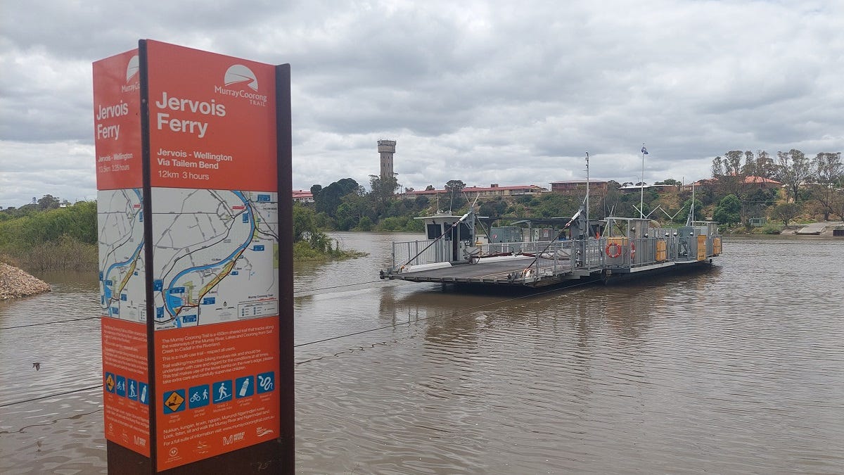
The ferries at Jervois and Wellington, along with those further upstream, were likely to close for several weeks during the floods’ peak, the Department of Infrastructure and Transport’s Donna Gray said.
The only river crossings to remain open would be the Swanport Bridge and the Murray Bridge, which was already down to one lane each way.
“It’s going to be inconvenient … no doubt about that,” she said.
Riverfront parks and roads would also be progressively closed as the floods came closer, Murray Bridge council CEO Michael Sedgman said.
Floodplain farmers won’t be the only ones affected
With the ferries closed, much of this summer’s grain harvest – if it ever dries out – will have to be transported across the two road bridges.
That was just one of the ways in which Murraylands farmers would be affected by the floods, Primary Industries and Regions SA’s Barb Cowey said.
Riverland irrigators had suffered when their pumps went underwater, or when the power to those pumps had been switched off – there had effectively been floods on the plain and droughts on the high ground.
And, of course, those farming on the swamps needed to plan to save livestock and infrastructure in the event of a levee failure – more on that below.

Tap water quality may suffer
SA Water’s Joshua Zugajev said Murray Bridge’s water supplies were safe, and tap water would remain safe to drink.
However, it might take on an “earthy or musty” taste or smell as nutrient-rich black water flowed down the River Murray.
Essential services such as power and sewage would be switched off in areas at risk of flooding, and potentially to some nearby households as well, but would be left on for as long as possible.
River levels are unpredictable
We know it will take about two and a half weeks for floodwaters to flow down from the Riverland.
We know the floods are likely to be significant.
But predicting river heights was an inexact science, Ms Zakrzewski said.
“There are probably a number of you … that may have seen the 1974 flood level, so a lot of you know what’s coming,” she said.
“(But) it may still look different from what you have experienced in the past or even to what the mapping is showing at the moment.”
With various amounts of water coming down the Murray, Murrumbidgee and Darling, forecasts would continue to evolve, the Department for Environment and Water’s Chrissie Bloss said.

Will the levees hold?
That’s the big question that remained unanswered after Monday night’s meeting.
DEW is expected to publish an updated map of levee heights along the Lower Murray any day now.
Previous maps, using measurements taken in 2011, showed that most of the 23 levees between Woodlane and Wellington – including those protecting Mypolonga and Jervois – were at risk of being breached at the river levels currently forecast.
However, irrigator Clem Mason told the meeting he was still optimistic.
“With the help of God, we’ll be right,” he said.
“220 (gigalitres per day) most of the levee banks are going to handle.
“Go back to 1956, that’s when they didn’t – that was 350GL a day.
“We almost saved them in ‘56 with sandbagging, and the levee banks were half what they are now.”
If the levees broke, it would only be because they had been poorly maintained, he said – and if that happened, people would know who to blame.
“These levee banks, built by government, set up by government, maintained by government, are the responsibility of government,” he said.
- More information about river flows: www.sa.gov.au.
- More information about flood preparedness: www.ses.sa.gov.au.
- Get help: Call the SES on 132 500 or, in a life-threatening emergency, call 000.
Your support can help Murray Bridge News tell more important local stories – subscribe today.


