Walk of the month: Narooma Wetland, Murray Bridge
Graham Hallandal guides you around one of Murray Bridge's hidden gems before it becomes better known.

This post was contributed by Graham Hallandal.

Over the coming months, our featured walks will be around the Murray Bridge township.
Early morning or late afternoon starts on warm days avoiding the heat will allow you to enjoy some of the areas of Murray Bridge you may not have known existed.
This month, our walk takes us in a circuit around Sturt Reserve and the Narooma Wetland to Long Island Reserve.
There are three optional start points for this walk – choose the one most convenient.
It is, for the most part, also suitable for bikes.
It uses a new trail, the Tumbella to Wharf Trail, recently constructed by the Rural City of Murray Bridge; and passes the new RSL memorial, a part of the first section of the Sturt Reserve upgrade and the new Regional Rowing Centre building.
This description is from a start at the wharf on the riverfront near the rail bridge.

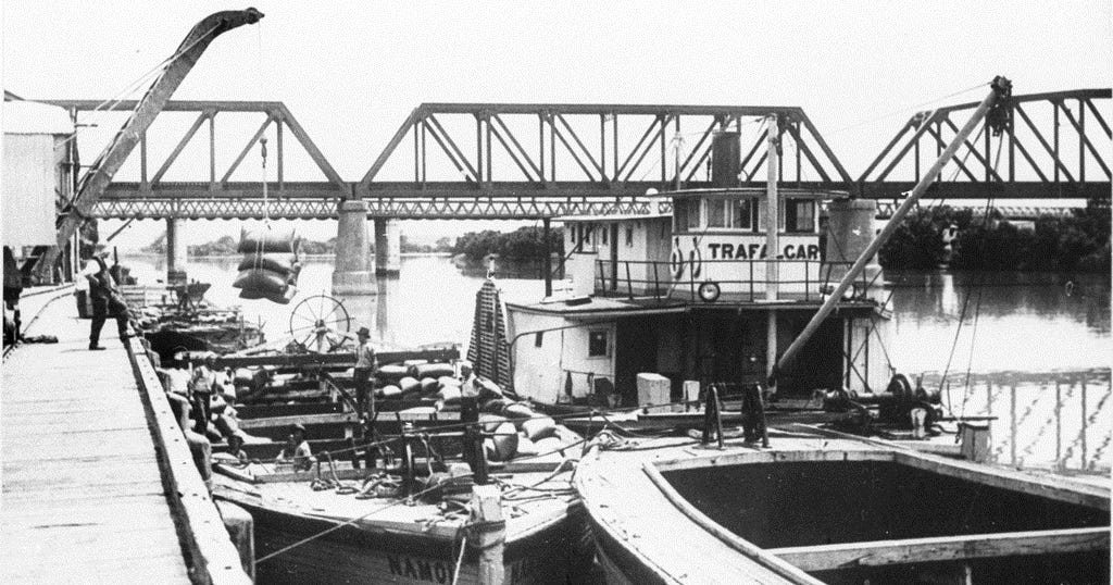
Originally of two levels, the wharf was 190 metres long with a further 145 metres of sheet piling at deck level and was serviced by two rail lines.
The crane on the wharf has a National Trust plaque and was one of six used to transfer freight from ship to rail.
It was not uncommon to see up to 20 streamers and barges at the wharf at one time in the 1920s and 1930s.
The historic wharf and rail yards now feature old broad-gauge freight cars and a steam loco, now isolated from the main rail line, which was converted to standard gauge in 1995.

Head away from the river along the path leading to Wharf Hill’s gardens and the Bridgeport Hotel.
The milk boat Union of the 1920s is to your right, with other historic items awaiting restoration.
It was brought to this location from the South East, where it had been used as a crayfish boat.
Deviate to the left to the new RSL memorial.
Wharf Hill’s gardens will be a part of next month’s walk.

From the RSL memorial, head south around the back of the lawn tennis courts, the side furthest from the river, and cross Sturt Reserve Road.
Charles Sturt Drive is on your right and the skate park to your left.
Head past the skate/bike course feature across the lawns and cross Jaensch Road to the track running between the back of the houses on Wetlands Court and the Narooma Wetlands.
This is the new Tumbella to Wharf Trail, recently opened, which will form part of the next section of the 450-kilometre Murray-Coorong Trail, Cadell to Salt Creek.

The wetlands currently have a lot of bird life to look at.
Part way along this section, the remains of a pump sump, used when the land around was used for market gardens, can be seen.
Further on, the trail swings towards the river, with an opening accessing Long Island Reserve.

River access, shade, shelters, a barbecue, playground and toilets are available at the reserve.
Long Island Reserve is an alternative start point for this walk.
You can also add to this walk by heading 700 metres along Wildens Way to Tumbella Reserve, another alternative start point for the walk, dotted red on the map.

This takes you past the back of shacks that recently were a part of a controversial community land agreement.
Leaving Long Island Reserve, retrace your track over Long Island Road but once on the track, this time turn right towards the river.
Follow the track upstream behind the shacks.
Only a few now remain.
This allows river access in a few locations and an ideal quiet place for fishing or just to sit and relax.
Unfortunately, not all demolished shacks have had their debris removed and in one location is an abandoned boat wreck.
At the Sturt Reserve end are fences and a locked gate.
If you go to the river’s edge, there is a small gap to walk through.
Follow the path upstream, past the bunyip to the Riverscape restaurant.
At the time of publication, the riverfront was temporarily blocked off for the Sturt Reserve upgrade project, requiring a detour.

When reopened soon, the new track, widened for multi-use will take you past the new Regional Rowing Centre, a $2.5 million project between the Rural City of Murray Bridge, Murray Bridge Rowing Club, Commonwealth and state governments.
This location has historical significance, being the site for the SA Farmer’s Union milk and cheese factory from 1922 until the time of its demolition in 1986.
Milk collected from dairies along the river by riverboats was unloaded and transferred into the factory.
Between the rowing centre and the boat ramp, an area is under construction for an information bay.
This will contain historical information; information on trails available within the RCMB, including local and regional trails and the Murray-Coorong Trail; and will be the new trailhead location for the Lavender Federation Trail.
Signs will include maps and photos.
It’s now just a short walk back to the start point.
The total distance is about five kilometres.


